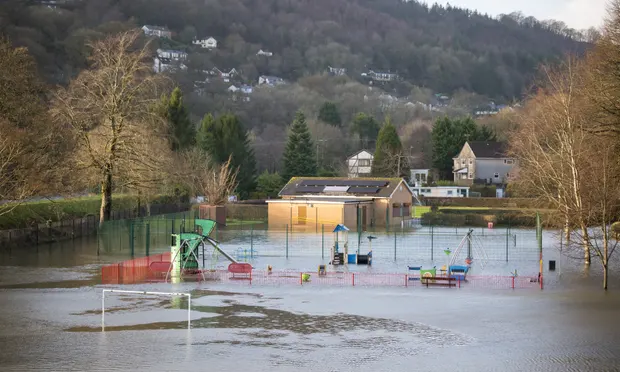
Forecasters have warned that Thursday’s predicted winds in some parts of the UK might reach 60 mph (97 km/h), which could cause heavy rain to flood some homes and businesses.
For all of south-west England, Wales, Herefordshire, and Shropshire, the Met Office issued a yellow weather warning for rain from 9 p.m. on Wednesday until 5 p.m. on Thursday.
It warned that some higher ground could receive 70 to 90 mm (2.8 to 3.5 in) or more of precipitation, adding that heavy downpours could flood homes and cause power outages.
According to the Met Office, excessive rain may also cause delays or cancellations on public transportation, hazardous driving conditions, and road closures.
The South Wales fire and rescue service reported that Porth and Pontypridd were the districts most severely impacted by flooding, while the National Grid reported that roughly 600 residences in Wales, mostly in Newport, were without electricity.
Read also: Research: UK could face ‘banking crisis should City fails to prepare for fossil fuel collapse
Four railway lines, including Cardiff Central to Caerphilly, Pontypridd to Treherbert, Abercynon to Aberdare, and Bridgend to Llantwit Major, according to Transport for Wales, are shut.
Aerial photographs revealed regions near Tewkesbury, Gloucestershire, were underwater on Wednesday due to heavy rain.
The Met Office had warned that “very strong west or south-west winds are expected, producing gusts to 45mph inland and 60mph along some coasts and across the high ground, with the peak in the winds most likely on Wednesday night”.
It urged people travelling to “take a little extra time” to make their journey safe in the “strong, gusty winds”, adding that some communities could be cut off by flooded roads.
The Office’s meteorologist Aidan McGivern said: “With all that wet weather coming in, there are concerns, particularly for those areas that have already seen so much rain across western England and Wales. The wettest weather is likely to see 60-80mm falling across the Brecon Beacons and Exmoor.”
For locations in England where flooding was anticipated or possible, the Environment Agency issued 35 flood warnings and 114 flood alerts.
Along portions of the Severn, Vyrnwy, and Teme Rivers, Natural Resources Wales issued 38 flood alerts and eight flood warnings. Newport city council closed a footpath on Wednesday after part of it collapsed into the River Ebbw.
Mark Garratt of the Environment Agency said on Wednesday: “Continued heavy rainfall across England means that minor localised surface water and river flooding is probable in parts of the Midlands and the south-west of England today, with impacts potentially continuing throughout the week.
“With the ground already saturated, communities in these areas should check their flood risk,”“The Environment Agency is monitoring flood levels, operating flood gates and barriers at locations across the country, and ensuring debris screens are clear from blockages to ensure communities are better protected”.
“We advise people to stay away from swollen rivers and urge people not to drive through flood water, as just 30cm of flowing water is enough to move your car,” she continued.
The Met Office predicted that Saturday will bring more steady rain, with the largest amounts likely to fall farther north, notably in Scotland, northern England, and north Wales.
This story was adapted from hull daily mail.
